ALTITUDE SICKNESS

Altitude sickness is something that too few people consider when taking on a climbing expedition. Whether you are a first time climber or a seasoned veteran, it can never be too soon to consider the risks and effects of altitude sickness and think about how to prepare for it should it hit you.

It is quite common for people to think that extra weight around the middle or a general lack of peak fitness are the root causes behind altitude sickness, but in truth that is just not the case.

Is Altitude Sickness Random & Unpredictable?

Research on the Internet may indicate that altitude sickness is caused randomly and is unrelated to a person’s age or level of aerobic fitness. You may also see information that acute altitude sickness comes on all of a sudden at specific altitude levels. Whilst weight can be a factor, how one person’s body is affected is not predictable with any accuracy and there is little causation that one can point to.

However, this sort of information is only useful when taken in context. The tests for altitude sickness for research purposes are typically performed by taking someone from sea level up to an elevation of several thousand meters quickly, and then seeing the effects. Much like with surfacing too quickly when scuba diving, it is not always the depth or elevation involved, but the speed with which you move upwards that matters.

As a side issue to be aware of, somebody who suffers from a respiratory disease like asthma is much more likely to experience breathing difficulties at higher elevations, if not altitude sickness specifically.

How Do You Avoid Altitude Sickness Ruining Your Trip?

The most important thing to do is to arrive ahead of your planned climbing trip and give your body time to adjust as gradually as possible to the level of elevation. This cuts down the risk of experiencing a bout of altitude sickness and the unpleasant symptoms that can occur from it. Given time, the body can adjust partially or completely to the changes in altitude, but when deprived of the time to adjust, the human body has the hardest time coping.

So for those travelers that are genuinely concerned about it, we would suggest planning for a longer trip, adding in time to adjust to the elevation initially, and perhaps selecting a climbing route or climbing course that takes a more leisurely pace.

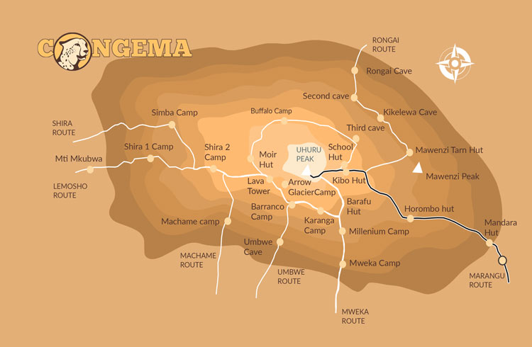
MOUNT KILIMANJARO ROUTES

null

Marangu Route

Distance: 72 kilometers
Days to traverse: 5 to 6
The Marangu route is one of the more popular tourist trails because it is
very easy to traverse. This path blazes through the southeast side of the
mountain starting from the Mandara hut. Its ascension levels are gradual
and steady, making it ideal for the tender-footed mountain explorers.
You'll also get a scenic view of the rainforest section and moorlands.
Unfortunately, it has a poor acclimatization profile and it locks
climbers into one part of the mountain only.

null

Lemosho Route

Distance: 70 kilometers
Days to traverse: 7 to 8
It is one of the newer routes that cover the western part of the
mountain. Although it is a difficult trail to follow, most Kilimanjaro
outfitters enjoy this road because only a few people go here. Plus, it
has hidden scenic views and a good acclimatization profile.

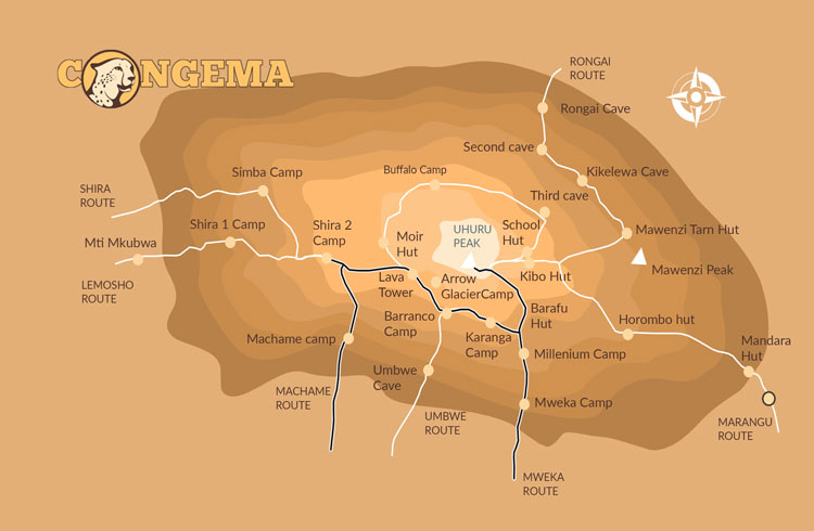
MACHAME ROUTE

Machame Route

Distance: 62 kilometers
Days to traverse: 6 to 7
It starts in the southwest area of the mountain, and the descent is down
in Mweka which is found in the southeast. In this route, you will be able
to visit stunning places such as the Shira Plateau, Barranco, and Lava
Tower. It is a perfect trail for expert climbers who want to test their
skills.

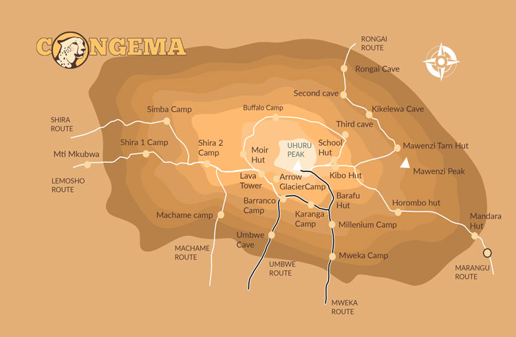
umbwe Route

Umbwe Route

Distance: 53 kilometers
Days to traverse: 5 to 6
If you want some challenge, you will get it here in the Umbwe route. It
is a very steep and constantly straight climb to the top that will surely
make you sweat. The success rate is very low because climbers do not have
adequate time to adjust to the altitude.

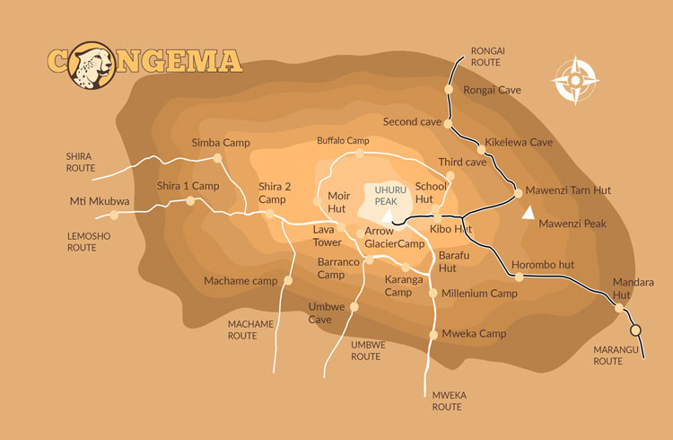
Kilimanjaro Rongai Route map

Rongai Route

Distance: 73 kilometers
Days to traverse: 6 to 7
It is the only path that approaches Mount Kilimanjaro from the north side
and is near the Kenyan border. Similar to Marangu, it is also easy to
traverse and it even has a good acclimatization profile. If you want to
explore peacefully while viewing a beautiful alpine desert, this is a
good alternative. You will even get the chance to explore remote and wild
areas.

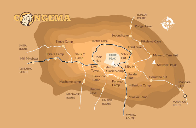
Northern Circuit Kilimanjaro

Northern Circuit

Distance: 56 kilometers
Days to traverse: 7 to 8
Just like Lemosho, this one is also pretty challenging. The first section
of the route requires you to drive around it rather than hike. This means
that you will greatly miss the rain forests. This means that you have to
pay an extra fee for the added transportation.

WHY CLIMB KILIMANJARO WITH CONGEMA

EXPERT GUIDES

  • Handpicked, licensed local guides
  • Years of climbing experience
  • Certified Wilderness First Responders (WFR)
  • High summit rate

BEST SERVICE

  • Rugged, four season Mountain Hardwear Tents
  • Super warm Mountain Hardwear -30F sleeping bags
  • Delicious meals made from fresh, local ingredients
  • Clean water treated with Water Guard
  • Spacious mess tents and private toilets

HAPPY CLIMBERS

  • Great experience!
  • Very well planned & organized
  • Excellent service all around
  • A solid company
  • Highly recommended!

Book your trip and climb Mount Kilimanjaro with

CONGEMA SAFARIS

for friendly, courteous service!